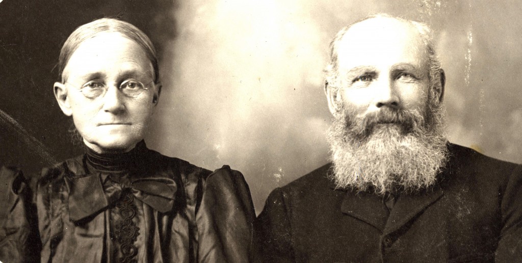
Maria and Robert Acton
During the 1850’s the railway line from Montreal reached Smith Falls, then continued on to Toronto, and finally reached Guelph in western Upper Canada. From Guelph, a wagon road ran north to Mount Forest on the edge of Grey County near the newly opened land called the Queen’s Bush.
In July of 1859 Robert J. married Maria Holliday and soon moved with her
and her entire family to settle some of this new land near Mount Forest, Normanby Township. By 1861 Robert J and his family appear on the census for Normanby Township, Grey County,Upper Canada.
Robert J. settled on Concession 2 Lot 60 and his father-in-law George Holliday settled on Concession 2 Lot 64. This is about 3 miles by road from Mount Forest.
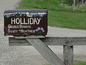
The original Acton homestead, still in the Holliday Family
The Township of Normanby, named after the British nobleman of
that name, lies at the S. W. corner of Grey County,
having the Township of Bentinck on the North, Egremont on the
East, the Township of Minto (in Wellington County) on the South,
the Township of Howic (in Huron County) at the S. W. corner, and Carrick
(in Bruce County) on the West.
At the time, Normanby was considered to be one of the best townships
in the County, one of the newest, and by the census of 1861 the most populous.
Garafraxa Road (forming Normanby’s Eastern boundary) was surveyed in 1841.
At that time only one parallel Concession on each side was laid out, but in 1845,
a second and third tier of lots were laid off on each side.
These constitute what may be called the “Old Survey” in Normanby and other townships.
The front lots were given in 50-acre “grants” to actual settlers, and the road soon
began to be lined with a thin fringe of settlements. In 1851 (or early 1852)
the survey was finished. The “New Survey” lots were first offered for sale
by the Government in 1856. For a year or two before that date, however, there
had been a great influx of German immigrants, filling up Carrick, and parts of Normanby,
Brant and Bentinck.
An early description of the area stated: “The Saugeen River, in its passage from Mount Forest to Hanover, divides the township diagonally into rather unequal parts, the N. E. being the larger. The part S.W. of the river is the finest part of the township, and is chiefly in the hands of the Dutch. While there are some beautiful lands at different points on the Garafraxa Road, the Eastern part of the township has a considerable amount of swampy and gravelly land. The prevailing soil in Normanby is clay”.
In 1861, Population was 3,963 persons; of which 708 were from Ireland and 628 were Dutch or German.
There were 18 schools with 416 pupils.
Crops raised: Fall wheat, 1,902 bushels; Spring Wheat, 78,378 bushels;
Barley, 3,448 bushels; Pease, 8,261 bushels; Oats, 39,160 bushels;
Potatoes, 37,905 bushels; Turnips, 171,360 bushels;
Hay, 1,862 tons; Maple Sugar; 14,694 lbs; Wool, 3,921 lbs.;
Butter, 62,062 lbs.; Cheese, 865 lbs.; Pork, 830 brls.
Robert J. lived here for most of the rest of his life.
His last years were spent living with his daughter Sarah Emily and her husband George Whetham in Toronto, where Robert died.
Robert, Maria, Sarah and George share a headstone in the Mount Forest cemetary.
There are no Actons living in Mount Forest today.
There are however Hollidays, Kirks, Lamonts and Whethams.
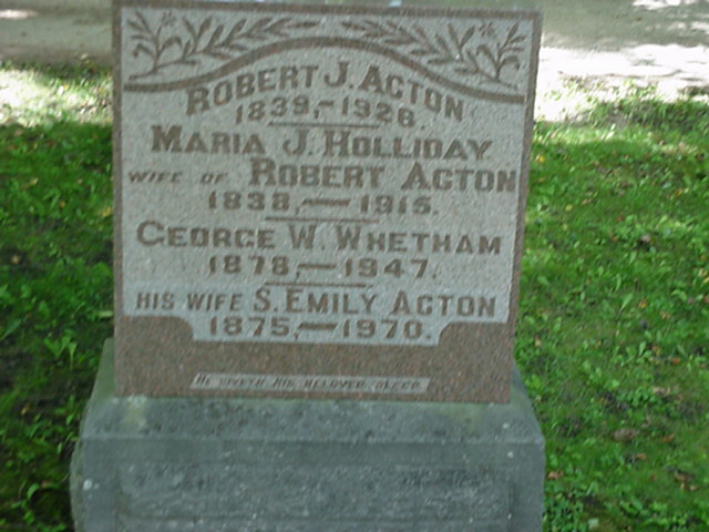
Gravestone Mount Forest Cemetery